About 1 year ago I created a post about Creating maps of ham radio contacts utilizing Ham Radio Deluxe. That process required using Ham Radio Deluxe as well as having some way to host the generated KML file. Well recently I’ve switched to using DXLabs suite of ham radio logging applications and the feature to create maps isn’t yet part of the suite. So what’s a ‘ol developer to do but go ahead and write his own solution. So here I’m announcing the available of a web application that reads in an ADIF file of ham radio contacts exported from your logging program and a way to create a Google Map showing those contacts. ADIF to Map is now available.
The ADIF to Map web application requires your logging program to associate a latitude/longitude or grid square with each record. Most logging programs allow you to capture this information (lat/lon and/or grid) but it normally needs to be entered by you or populated via a callbook such as QRZ or HamCall to name a couple. I use QRZ and their XML subscription service ($29.95/yr) and it’s well worth it. If you don’t make a lot of contacts, some programs support population from QRZ without a paid subscription but the number of lookups is limited. Without a latitude/longitude or grid square associated with each contact, there’s nothing to map.
ADIF is a standard format used by most all logging programs to import/export data. You’ll need to find out how to export an ADIF file from your specific logging program. Over time I might add some steps for the more popular ones to the FAQ, but there are so many different logging programs in use I wouldn’t be able to keep it up to date. When you export an ADIF file, you’d create a local file on your computer, so note the location of that file.

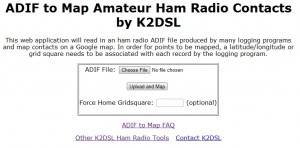
Once you have the ADIF file local on your computer, visit ADIF to Map and click on the Choose File button and select the ADIF file. There’s an option to specify your home QTH as some logging programs don’t export the information. If you’re not sure or want to specify your home QTH grid square, enter it in the box provided. Once you’re ready, press the Upload and Map button and depending on the size of your ADIF file it could be a few seconds to a couple of minutes before you see the contacts displayed on a Google Map.

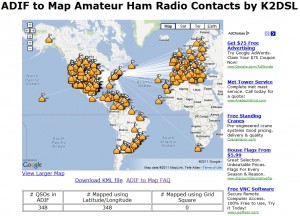
Hopefully the map displayed your exported contacts, but if you received unexpected results, check the FAQ for some ideas on why. Each point is clickable and will display the call of the station and depending on the data available in the ADIF export also the QSO date,time, band and mode of the QSO. There’s also a link under the map to display the map in a larger view which will give you a full screen Google Map of the same data. There’s also a link to save the generated KML file to your local computer. This is the file the web application creates for Google Maps needs and can also be read by Google Earth if you have it installed on your local computer. The created KML files used to map your contacts are stored only for 1 day, so if you want, save a copy locally. You can always re-upload and map your ADIF file.
As a reminder, each contact record in your logging program needs either a latitude/longitude or grid square associated to it which should be exported in the ADIF file by your logging program. If that info isn’t there, nothing will be mapped.
I’ll be adding some additional features to the application as well as handling any reported errors you might find. Though ADIF is a standard, there are likely different logging programs that interpret that standard slightly differently and I might need to adjust the application to support it. If you find something that isn’t correct, please let me know by referencing the FAQ on The application generates an error.
I hope you enjoy the application and please provide me with any feedback you have or issues you encounter.
73 & Happy Holidays!
K2DSL

